Structure and Geographical Location of the Lohgarh Fort
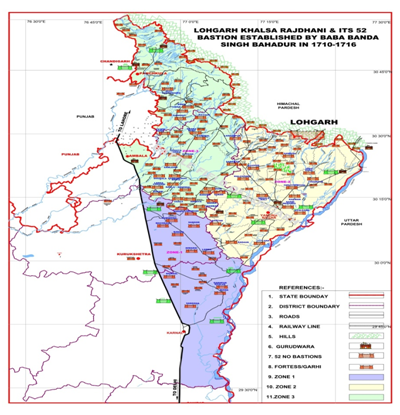
Fortification of the Lohgarh Fort was made in a huge area to deal with the mammoth army of the Mughals and a strategic planning of the defense was made keeping in view the Mughal warfare. The epicenter of the Fort is spread in almost 7000 acres which is situated in the old State of Nahan, in the present Yamuna Nagar District of Haryana and Sirmaur District of Himachal Pradesh. The archaeological evidence, along with time and motion study of Lohgarh Fort shows that it must have taken about 70 to 80 years for completion of the Fortification work of such a large area.
The Lohgarh Trust Yamuna Nagar has collected the evidences from Archaeologists and Engineers of Time and Motion study experts.[1] The area of the Fort is spread in revenue estates of Lohgarh, Haripur, Chile, Mehtawali, Palori, Sukron, Maharonwala in Himachal Pradesh, and, Bhagwanpur Nathori, Dhanaura, Nagli and Mohindinpur revenue estates of Haryana State; and, the circumference of this Fort is about 50 km. The Fortification of the bastions of the Fort Lohgarh existed right on the hills known as Dabar Hills and it is holistically an arc shaped ridge starting from the river Yamuna to river Markanda.The overall Fortification of the hills in the said area is extended about 60000 acres. For research work the Fort is divided into 32 sectors. The defense established before the Lohgarh Fort in plains, to check the advance of Mughal Army, was extended up to Ladwa & Indri (districts of Kurukashetra and Karnal).
After the Archaeological survey and after the intervention of Persian records, it has clearly come out that the Fortification/chowkies were established in the Shivalik Hills, in the present districts of Yamuna Nagar, Ambala (Toka Sahib area) and Panchkula (chowki village near Nada Sahib); (Forts still exist in Mansoorpur & Bavana). The last Fortification made by the Sikhs and Banda Singh Bahadur, are found near Pinjore. Banda Singh Bahadur striked at the Mughals over a very wide area ,extending from Jalandhar Doab in Punjab to Bareilly in Suba Delhi. So it is quite obvious that the Fortification were made on the shivalik hills from Punjab to Uttar Pradesh. At various points, nature was very skillfully used for defense purposes and the hills were cut for the generation of narrow passages, so that, in case the enemy army reaches a particular bastion of Lohgarh, the large Mughals army cannot enter all together in the bastions. As a part of strategy of defense through this narrow passage only a single soldier could enter inside the bastions one at a time. It was always easy to handle single moving soldier and the Sikh army even in less number always remained heavy on the Mughal forces due to their strategic defense positions and caused heavy casualties to the Mughal troops advancing towards Fort Lohgarh. Lohgarh Fort was constructed by common men, i.e. by Vanjara Sikhs and the Sikligars, who lived near the vicinity of Lohgarh Fort. This is the largest Fort of the world having defense comprising 200 hills on which strong ramparts of Fortification were made. This makes Lohgarh Fort the largest Fortification of the world, constructed so far. This is also the first time in the world history that the Fort was constructed by the people and not by any monarch.
The contour of first Fortification of the Fort commences at the height of 1200 feet above sea level and the last rampart of the Fort is found on the hilltop 1900 feet height. Each hill has an independent and separate defense system which also acts as a supporting protective system of other defensive posts. Such a unique Fort was built to deal with the world’s strongest army of Mughals. The Mughals had a mammoth army, equipped with the most sophisticated weapons of that time. As the strategy of war the Mughal army used to lay siege of the enemy Fort thus cutting the supplies of essential materials required for the sustenance of lives. The soldier in the Fort were compelled to surrender. The major part of a military campaign of Mughals frequently consisted of an extended siege of a town or a Fort with only a few minor skirmishes.[2] Mughal warfare was inflexible when confronted with guerrilla tactics.[3] In various incidents of this kind the Gurus had mustered troops from amongst their followers, the military exercises had been systematically encouraged, for building and towns in which a careful consideration was given to proper defenses.
In ancient times nature was used as a defense. Frequently the dense forest called as Vanh Durg and hills/mountains were called Parvh Durg. In the case of Lohgarh Fort and its battle field both the concept of Vanh Durg and Parvh Durg exist which was a great advantage to the Sikh forces. The geographical location of the Lohgarh Fort is such that, this place has dense forest on its North and South, the cumulative width of which is 14 km. the Lohgarh Fort was established as the Sikh State Capital, by Baba Banda Singh Bahadur in December 1709.The Sikh army not only had sufficient water but also had control over the water which flowed down to the enemy’s army. The Fort is designed in such a manner that it has a double Fortification system, i.e. one Fortification wall moves around the rivulet area and the other moves around the hill. The rivulets, passing through the Fort area, strategically bifurcated the Fort in such a fashion that each bifurcation system in exigency was in the protective support of the other area. Even if the enemy army succeeded in capturing any side, the whole Fort could not be captured at the same time as the Fort is divided along the rivulets and different protective defence belts. The Sikh army present in other parts of the Fort being at an advantage point could have easily reinforced and recaptured the lost portion. The bastions were established in such a fashion and position that each used to defend other. Watch towers/ chowkies were established strategically in such a manner that the view of the Som river is visible from every part of the Fort. Therefore, even when the Sikh army was outnumbered the enemy army failed to capture it because of its vantage point of defensibility. No cannons were effective on the strong impregnable walls of Lohgarh Fort. The flanks and rear of the Fort, were protected by narrow gorges and its face rested on nearly vertical slopes. The hill sides were overgrown with dense subtropical undergrowth, thick bramble, impenetrable mass of thorny shrub acacia, cacti, lantana bushes, therefore a large scale assault was not possible, from this side. Therefore, Lohgarh Fort was chosen with excellent defensibility. In case of sieze there were many secret routes to escape out of the Fort. It is not possible to construct such a huge Fort in a short span of one or two years, and that too on a terrain which is about 1200 feet to 1900 feet above the sea level in the Shivalik hills. This land is still densely forested area and for a normal man it is not possible to even to make surveys of the area for making its design. The area is rich in minerals of limestone and metamorphic rocks are available in ample quality. Hence the raw material must have been available on the spot for construction of the Fort. Lohgarh Fort was the capital having a model city with ample amount of water, food and ammunition.
The elevated ridges (1200 to 1900 feet) of Dabar (lowest hills of Shivalik) were chosen as the battle field which extended from Udhamgarh (near Kala Amb) to Kalesar and exactly the centeral point of the ridges was chosen for the Fort Lohgarh. On the North side, i.e. near Udhamgarh, Markanda river flows which emerged from the Shivalik hills and flows to the plain area after passing about 20 km along the hilly boundaries of Dabar Hills, touching its feet. The width of the river while emerging into plain area is more than 100 meter, but as it goes into and towards Dabar hills, its width goes on decreasing and becomes deeper with more and more high brims on both sides of the hilly areas. As the part of the strategy the Mughal army laid a siege from 1710 to 1716, but it failed to achieve the stereotype objective. Now a days, along the side of Markanda river, a metalled road has been constructed from Nahan to Paonta Sahib, through these hills. A dense forest having thorny bushes, cacti, sub-tropical grasses, marshy meadows extends from the boundary of the river up to the Lohgarh Fort wall.
The area between the wall of the Fort and Markanda river was thus thickly covered with impassable forest and Sikh army made ramparts and trenches at weak points to plug the entry of the enemy. These thick thorny forests were also used as hide points of Sikh army so that the enemy may be attached, suddenly in case of their entry from this side. It was impossible for the Mughals to make the estimate of arrangements made by the Sikhs in anticipation of a big war. There are many Khols (small rivulets) such as Haripur Khol, Lohgarh Khol which fall into Som River and make it a medium size river.
There is another river Boli Nadi, in the South side of the Fort, which touches the Dabar Hills foot beyond 10 km before it emerges in the plain area. This river is a seasonal one which flows heavily in rainy season, and brings sand down the hill in the river bed. This sand has gold particles and even today the district administration Yamuna Nagar, leases out the river beds for extracting gold. The Hill side of the river, having steep rise and some weak points was plugged with a heavy entrenchment up to the approach of Lohgarh Fort. There are other Khols such as Nagli Khol, which forms a big river called Pathrala, which makes a heavy discharge (30000 c.c. per second) of water during the rainy season.
The Southern side of Lohgarh Fort faces towards a plain; and, this area was used to produce food grains by the Sikhs. In between the plain area and the hilly area of Lohgarh Fort, Som river flows which finally makes its discharge in Yamuna river. It touches about 10 km from west with the feet of hills.
Khols and rivulets are passages which make approaches towards the Lohgarh Fort, which made the Fortification of the Lohgarh stronger because from the edge of Som river, hill slope were steep and had abrupt rise. This made the approach to Lohgarh Fort still tougher. Heavily ramparts entrenchments were constructed by the Sikh army to inflict heavy damage to enemy in case of attack from this side. A number of high pickets/Fortresses were raised, so that the enemy movement can be viewed from a distance.
The view of the Som river and its adjacent plain area are visible from high pickets/garhis. Many rivulets, ravines and many khols, emerging out from Dabar Hills, the flow of which falls in Som Nadi, ultimately emerge into Yamuna river. Light towers on the hillocks were constructed, with objective to guide guerrilla Sikh fighters in the night time, so that after making raids on Mughals camp, they could safely retreat back to Fort. The cotton seeds were burnt in a small pond on the tower, this process generated light, which was highly luminous and could be seen from far distance. 52 bastions existed on the southern side of the Fort, starting from Indri, Ladwa, bank of Yamuna and spreads in district YamunaNagar. Most of the war between the Sikh and the Mughal armies was fought in plain area where 52 bastions of Fort Lohgarh existed.
The Eastern side, which is the rear side of the Fort, is completely under a forest cover, which is now declared as the National Forest Park and now falls in the State of Himachal Pradesh. From Lohgarh Fort up to the towns of Paonta Sahib and Nahan, there is a thick wooded forest having bushes and sub-tropical grasses, where wild animals like bears, panthers, leopards, and tigers were often spotted in those days, and, hunters used to hunt them. At present all these wilds are kept protected in hedge made of thorny steel wires and tourists usually visit them through particular passages.
In those days, the approximate width of this forest was 8 km from the wall of the Fort. There were many secret passages to reach Lohgarh and were used for supplying essentials to the Sikh Army and in case of siege they acted as safe exit routes. From these passages Banda Singh, along with his troops, used to move towards Anandpur Sahib, Jammu and Chamba hills and also to the plain areas of Punjab for assault on Punjab cities. The Mughals were never aware of these routes. Moreover, these routes were properly entrenched with dressed stones so that the enemy could not take control of these passages. All the entry points from the front side to the rear side of the Fort were highly protected and Mughal siege was not possible from these directions of the Fort because of the Markanda and Som Nadi rivers and highly steep abrupt rise of hills from both sides. Only part of the front side, i.e. the southern side was exposed to the enemy attack.On this side of the Sikh army made pucca trenches and obstacles in most of plain area. Most of the war between the Sikh and the Mughal armies was fought in the plain area where 52 bastions of Fort Lohgarh existed. The siezure by the enemy on the front side, i.e. the southern side was not so effective, therefore, this lead to heavy damage to the Mughals during the war. The Lohgarh trustee explored deeply the area of the Lohgarh Fort with a good number of people because one could only enter it after cutting wild plants on the way. Lohgarh Fort, which is spread in 7000 acres, is divided further into sectors. So far 32 sectors of its area, which comprises about thousands of acres of land, have been surveyed. Each sector is situated on different hillocks. There are dual-protection walls enclosing each sector. The foundation of the ramparts could be seen especially at vulnerable points, which were properly plugged with stone walls. Each sector supported as a defense for the adjacent sector.
In case one sector was captured by the enemy, the other men sitting in the adjacent sectors could inflict heavy damage on them with their gunshots, as the area came directly under their range due to higher contours. Many areas of Lohgarh are still under exploration because it can be inspected only after cutting wild plants. The outer wall of the Lohgarh Fort is not found continuous. The foundations are clearly visible at vulnerable points. The foundation about 2.5 to 3 meters wide and it is not visible where the wall join steep rise of the hills. Fort’s outer circumference of the wall, including hill width is about 50 km. How could this huge Fort, which is further defended by the Fort wall around each sector, be conquered by the Mughal army in one throw and one day as narrated by some historians. As the strategy of war, the Mughal army used to lay siezure of the enemy posts, thus cutting their supplies of essential material required for the sustenance of life, compelling the defending forces to surrender; but, in case the Lohgarh siezure was not possible, the question of a shortage of supplies and further surrounding of Lohgarh never actually happened.
The geographical location and topography of the Lohgarh area is such that here the siezure of Mughals also was not possible. This area, having high contours hills with undulated land with thorny forest covers on one side, and steep a rise of hills on other side, surrounded by seasonal rivulets flowing along with their foot, made it highly defensive. Bahadur Shah, the Mughal Emperor himself reached Lohgarh in 1710, to free this Fort from the Sikh army. After reaching this place, he realized the gravity of the situation, i.e. the defensibility and invincibility of the Fort, and, he was compelled to move back without capturing it. Now the fear of collapse of the vast Mughal Empire hovered over his mind as a result of which he depression overwhelmed him due to which he became insane and died after some time.
For the construction of such a large Fort, a large number of men forces both skilled and unskilled i.e. in the shape of laborers, masons & architect were required. The Construction materials i.e. bricks, stone of different size, sand and crushed stone were the requirement a heavy demand; hence, the mission was supposed to be completed secretly without disclosing its objectives to the common man.
A systematic archaeological investigation of the site of the Lohgarh was conducted for months together and a large number of remnants pertaining to Fortification walls were found at Lohgarh. These Fortification walls bear the thickness from 3 to 4 meters. Such large and heavy Fortifications were done with anticipation of huge battle with the Mughals and the Sikhs had the information that the Mughals’ arsonary had the world’s best cannons including the small cannons which could be installed on the camels.
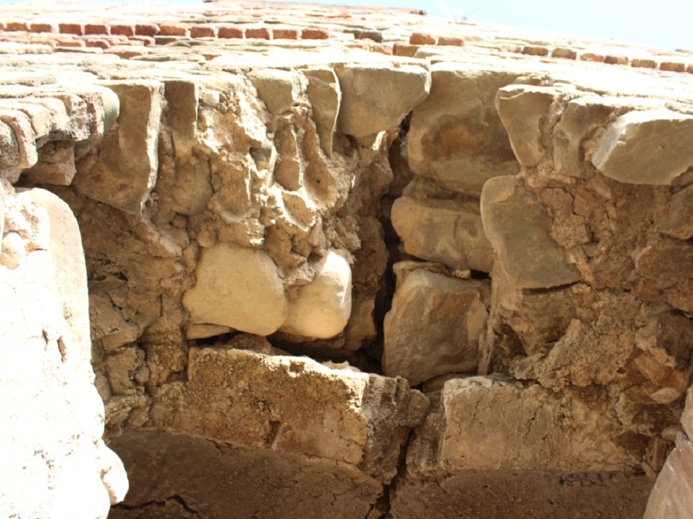
The Fortification wall was found around the Lohgarh Fort and this wall is made of Ashlar stone masonry using dressed blocks of given dimensions with faces perpendicular to each other and laid in the course by using lime motor as the binding materials. The masonry and the workmanship of the walls is wonderful.
The remains of the defense walls have been found in the Pahlori Reserve Forest. These archaeological evidences are located in the North east side of Fort the Lohgarh. The back side of this area is a dense jungle, which has now been declared as the Sher Jung National Park. We can make a walk of 10 km through the jungle from these archaeological evidences towards the northeast direction to reach Poanta Sahib. In the center, we find a place called Sukhchain Singh Tanda; there too archaeological evidences can be seen.
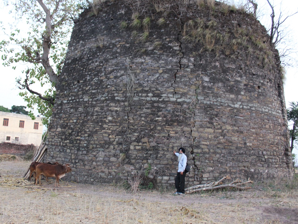
The foundation of bastion is found at in sector 30 of Lohgarh Fort. Presently there are only two layers of stone left on the archaeological site. The rest of the structure was demolished by the Mughals. It can be safely presumed that there has been a continuous erosion of soil due to rains in the area and that erosion has uncovered the foundation of the Bastion in the course of 300 years. This bastion is having the area of 50X50 ft.
Dregs of Parapets are found in sector 12 of Lohgarh Fort: This area is of strategic importance as it is situated near the forefront of the Fort. The thickness of the wall is about 3 to 4 meters. It is a masonry built of stones in regular shape and hammer dressed with comparatively thick joints and lime motor brick surkhi used as a binding material.
The blockage of stronghold found in the village of Nagli shows the archaeological evidences of the Fort Lohgarh. The stone masonry work was done here with number of lime mortar. The contour of the said area is at hillock and for the enemy this rampart was a major hurdle for the army to reach the camping area of the Sikh soldier. From this point only a few Sikh soldiers were able to confront the large Mughal army.
Heavy Fortification walls bearing thickness from 3 to 4 meters are found in sector 12 of Lohgarh Fort. This area is on the bank of Lohgarh khol and it was quite vulnerable to the Mughal attack in 1710. This area is flat from the front side having a big camping ground and the backside of this area is elevated and narrow, having a steep side and two khols touching both the sides flow and fall in the Lohgarh Khol. This area was a vintage point for the Sikh soldiers, it acted as a supply depot for the Sikh soldiers fighting in the front against the Mughal army. The tail of this Fortification touches the sector C-4 of Haripur reserve forest which was a very safe and invincible Fortification.
The remnants of ramp and strong hold lead to the hillock of reserve forest of Jhanda village of Haryana are found. After making the archaeological survey of the area a dual Fortification of the hills can be seen and from here a vast view of the plains, i.e. the battlefield of the Lohgarh; and, some of the 52 bastions of Fort Lohgarh were easily visible. The siezure of this area was not possible as there are steep hills and adjoining these hills the river Markanda flows. The supplies for the Sikh army were made from the back side of the Fort, which is adjacent to Nahan.
Remnants of Stone Barricades are found in the Nanhari reserve forest. This area is in the South east part of the Fort Lohgarh and is situated on the attacking site of the Fort. Geographically, this area is situated between the khols and a pass leading to Jafarpur Jafri village of Haryana.
Archaeological evidences are found in the reserve forest of Kotla. At the hillock of Kotla and the adjacent area of Himachal Pradesh there is a heavy Fortification on the hills and parts of Chakki. It shows that the kitchen of the Sikh soldiers was on the high contours, so that the food supplies and other basic amenities remained away from the control of the Mughals.
In the revenue state of Sangholi, on the higher contours, a random rubble masonry Fortification is found with stones of different sizes and shapes brought from the quarry of a bed of a rivulet flowing adjacent to the area. Lime motor and surkhi was used as the binding material. This area had a multi Fortification system as it was on the fore front of the Fort and these are vulnerable to the aggression by Mughal canons.
The historian Dr. Harjinder Singh Dilgeer along with S. Jarnail Singh, during his visit to Lohgarh, inspected the bastion and a watch tower in sector 16 of Lohgarh Fort. Of the foundation of the bastion, as found in sector 16 Lohgarh Fort, presently there are only two layers of stones left on the archaeological site. The rest of the structure was demolished by the Mughals.
During their visit to sector C-2 of Lohgarh Fort, they found that this sector is about 10 km deep inside the Fort and this is quite far away from the forefront of the Fort. The supply depot of the Sikh army has been found here.
Dregs of the parapets have been found in sector 17 of Fort. This area is of strategic importance as it is situated near the forefront of the Fort. Here the thickness of the wall is about 2 to 2.5 meters. It is masonry built of stones in regularly shape as quarried or squared and hammer dressed and having comparatively thick joints of lime motor having brick surkhi.
As far as Lohgarh Fort is concerned, only a rich person like Lakhi Rai could have built it. He had a force of hundreds of thousands of young workers (who had military training as well). A huge quantity of stones, lime and bricks were used to build this Fort. Such massive stock of construction materials could not have been brought by a couple of hundred persons. A ‘tanda’ (trade caravan) of hundreds of thousands or person would have brought all this. Lakhi Rai Vanjara already had experience of building about two dozen Forts and palaces. He had been a supplier of building materials (stone, lime and timber) for the Red Fort Delhi and some Maratha Forts.